Forgotten Realms Wiki
Advertisement
Forgotten Realms Wiki

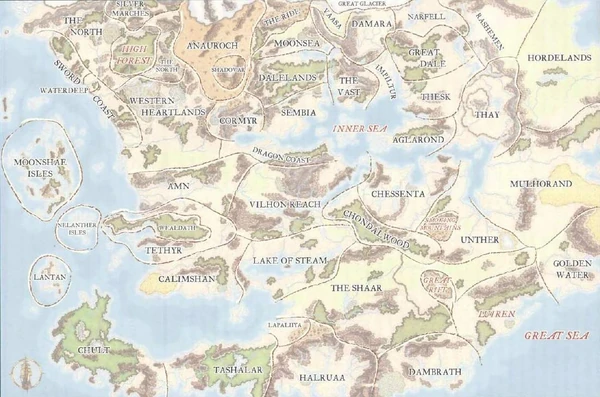
Official political map of Faerûn (a geography map with political borders) was first published in the Forgotten Realms Campaign Setting for Dungeons & Dragons 3rd edition. It is relative to the year 1372 DR. The map was updated to year 1373 DR in the Player's Guide to Faerûn. The following is the second revision of the map.

Note: For a non-clickable image and copyright status, see File:Faerun political.jpg.

Moonshae IslesNelanther IslesThe NorthSilver MarchesThe NorthSword CoastSword Coast NorthWaterdeepWestern HeartlandsAmnHigh ForestLantanTethyrWeldathChultAnaurochEmpire of ShadowsCormyrCalimshanDragon CoastThe RideMoonseaDalelandsSembiaVilhon ReachLake of SteamTashalarVaasaDamaraGreat GlacierThe VastInner SeaNarfellRashemenGreat DaleImpilturTheskAglarondHordelandsThayMulhorandChessentaUntherSmoking MountainsChondalwoodThe ShaarGolden WaterLuirenGreat RiftDambrathHalruaaLapaliiyaPolitical boundaries of Faerûn
About this image
Advertisement